The Holocene evolution of a coastal barrier complex, Pendine Sands: Stuart Walley 1996
This study by Stuart Walley is a comprehensive data gathering exercise for which the point of departure is the underlying geology of the area. The research provides substance for insight into the evolution of the Pendine Barrier and the impact this has had upon morphological change in the Taf Estuary.
Although the conclusions reached by Walley are vital to this study, how he got there and the multidisciplinary processes used to evince data, would be too digressive for our purposes. Indeed, it would not be doing his research justice to attempt a summary, since it deploys methodologies as diverse as the use of seismic refraction to determine the nature of the bedrock, the extraction of core samples from which mineral deposits might be traced, radiocarbon dating carried out upon foramifera samples and the analysis of pollen samples. All of this and much more besides renders a comprehensive picture of the evolution of the Pendine and Laugharne Barrier system and the influence this has had upon the sedimentation of the Taf Estuary and the development of its saltmarsh sites. What follows, with reference to Walley’s text and support from Thomas van Veelen is my understanding of the key stages of the development of the barrier complex, the history of human intervention and the effect this has had upon its continuing evolution.
The formation of the barrier relies upon two key geological features:
- A ridge of glacial till deposited during the Pleistocene period anchors the western portion of the barrier.
- A fossil cliffline runs from Gilman Point barrier approximately northeast to the hard outcrop of Coygan and Sir John’s Hill; this feature also marks the southernmost limit of the glacial ice sheet and shows no evidence of wave erosion. The reason for this is the underlying ridge, which fixed the onshore surf line. However the cliffs of Sir Johns Hill remained exposed to weather and wave action until the time that the barrier extended sufficiently eastward to create a shadow area.
The early development of the barrier:
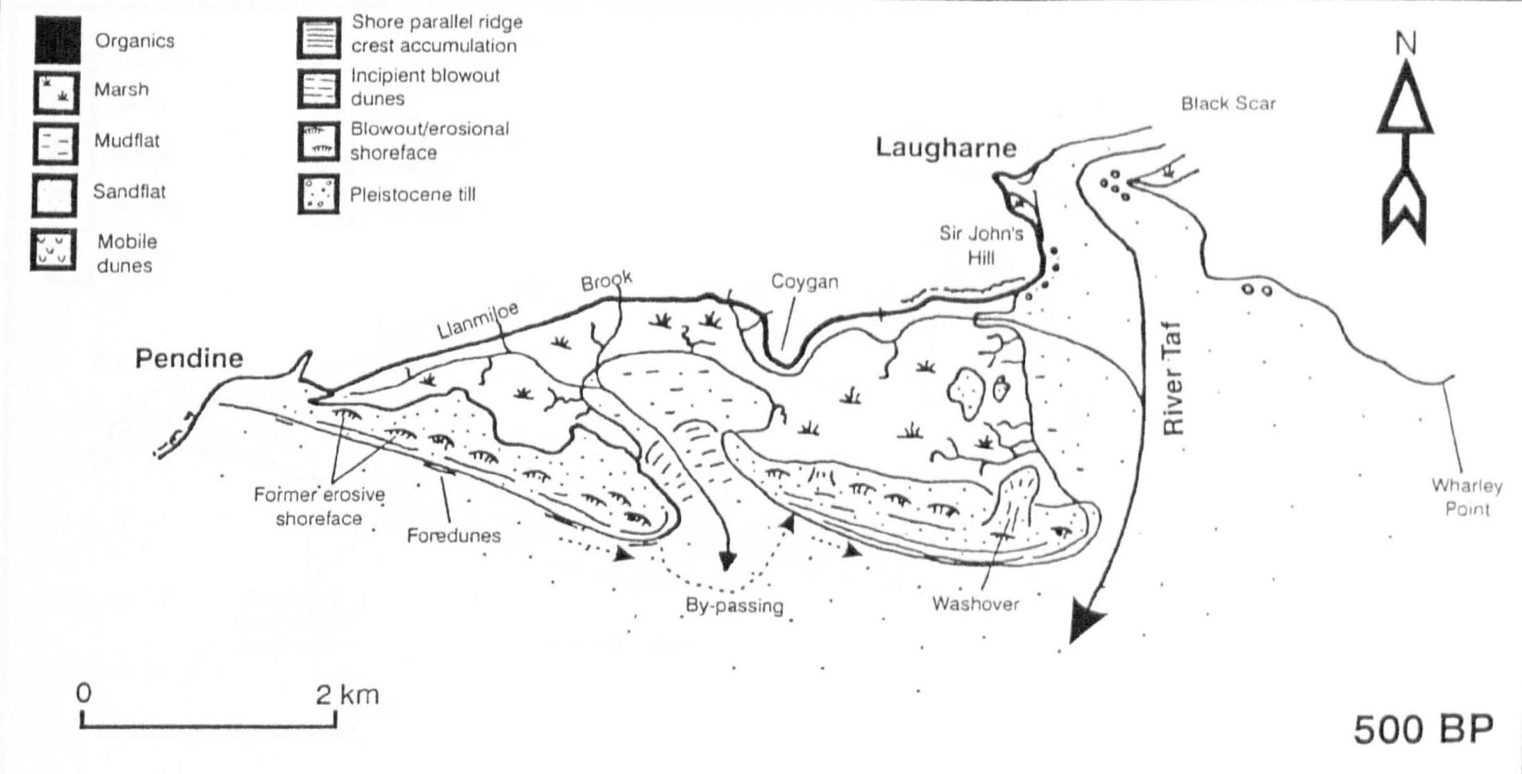
- Although the development of the barrier was inconsistent it underwent two key periods of stability between 6,200 – 5,700 and 4,500 -3,500 years BP. These were times of progradation and spit development from sediment deposits in Carmarthen Bay.
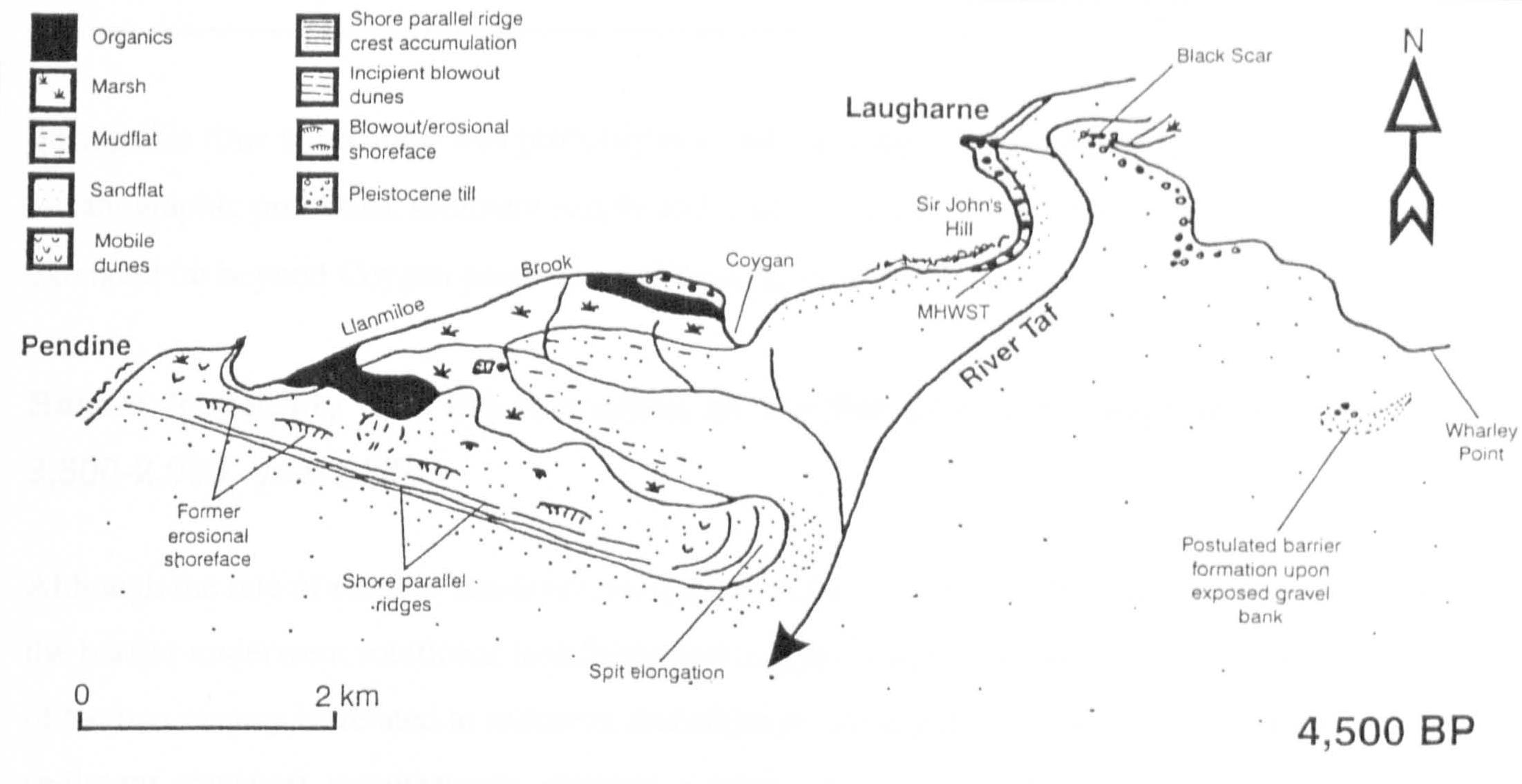
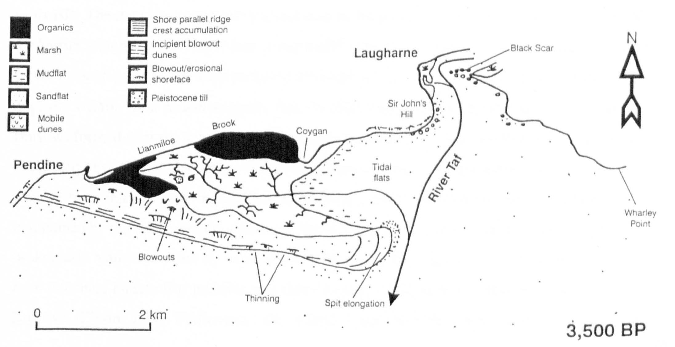
- Those periods of instability and breakdown were most likely caused by periods of storm, but the ridge beneath the western portion of the barrier prevented total breakdown of the system.
The subsequent evolution of Pendine and Laugharne Burrows:
- As the Pendine Barrier developed eastwards it forced the meltwater channel Wytchett Brook further east to drain into the tidal flats sheltered by the distal end of the barrier.
- In the period around 2,000 BP a period of instability caused the barrier to breach and a tidal inlet to form connecting with Wytchett Brook.
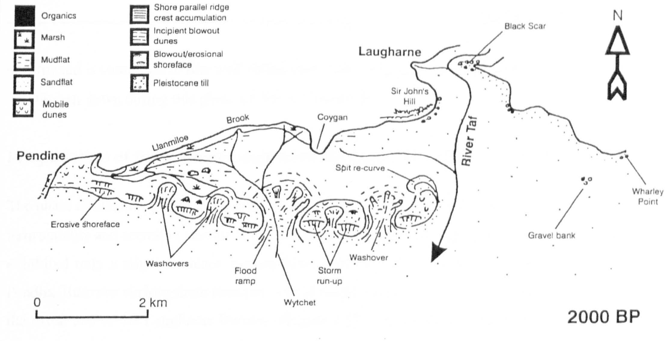
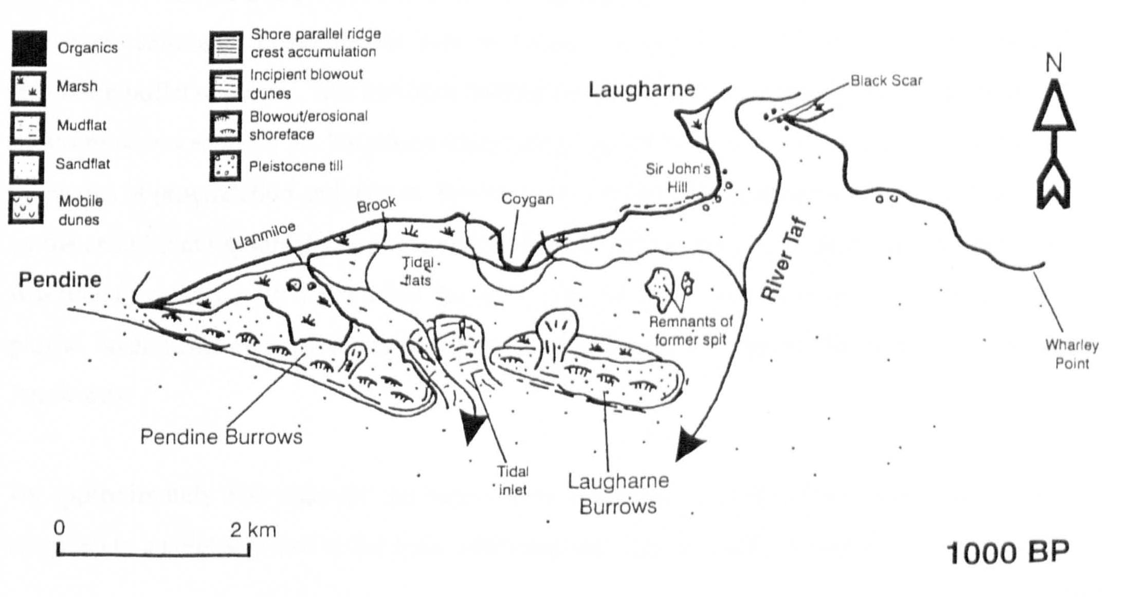
- Wytchett Inlet remained active as a tidal exchange until the 17th century. The section of the barrier to the east of the inlet, nominally Laugharne Burrows, continued to prograde eastwards with periodic breaching and breakdown.
Although there is abundant evidence of prehistoric human activity on the lower Taf, which includes the human settlement at Coygan uncovered and destroyed by the quarrying activity, a substantial shellfishery at Laugharne Burrows dating from the stone age, and a history of the use of the back barrier marshes for pasture, it was not until the medieval period and after, that communities actively took advantage of the shelter afforded by the dune barrier. At this time Laugharne was also growing in importance as a sheltered trading port, equally connected to the sea as to its hinterland, and located strategically to command its seaward approaches (Tyler 1925).
However, it was not until the 17th century that major human intervention to manage the barrier and the back-barrier marshes accelerated the process of change in the reciprocal dynamics of the geomorphology of the site and the rate of sedimentation within the River Taf Estuary (James 1991).
The barrier after human intervention:
- The continuing progradation of Pendine and Laugharne Burrows eastward created an extensive fresh and salt water marshland in the back barrier area that was already being used as pasture at the higher end of the West Marsh. Evidently, by the 17th century, when there was sufficient interest in its potential for financial return as a grazing marsh, it was considered stable enough to be a candidate for reclamation.
- In 1660 Sir Sackville Crowe had a seawall built across Wytchett Inlet and the back barrier, and an embankment connecting the foot of Sir John’s Hill and the distal end of Laugharne Burrows. Together these transformed the brackish back barrier marsh into a fresh water grazing marsh. In the first instance the accumulation of fresh water in the back barrier marsh was drained into Witchett Brook and via a sluice out over Pendine Sands.
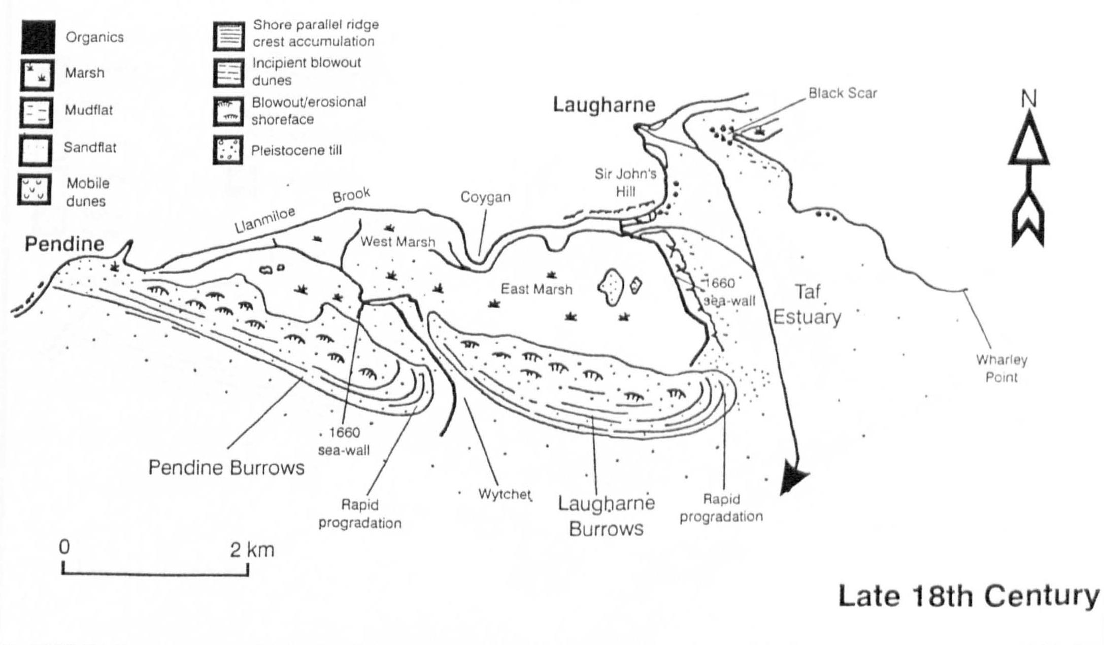
- Between 1800-1810 George Watkins of Broadway caused a further embankment to be put in place to enclose the Lower Marsh and link it to Ginst Point at its location at that time. As a result of this and since then the barrier has continued to prograde further east and within the past century a further area of saltmarsh has been generated within its shelter.
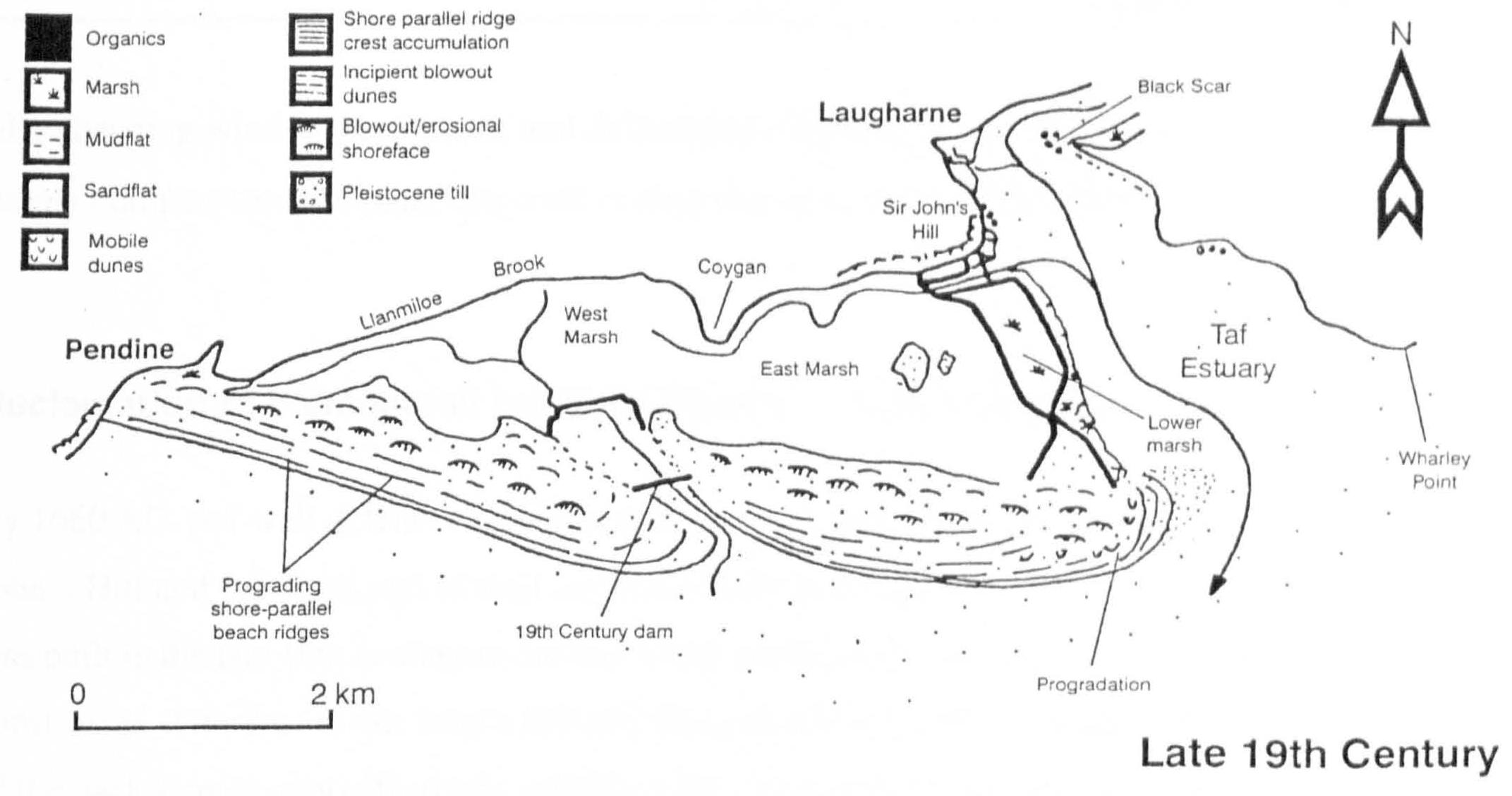
- By 1840, two dams were constructed: one across Railsgate Pill at the foot of Sir John’s Hill and the other across Wytchett Inlet. These acted to further consolidate the reclaimed marshland and at Wytchett Inlet, enabled Pendine Burrows to join up with Laugharne Burrows, effectively impounding the relic of Wytchett Brook as a freshwater lake.
The contemporary configuration:
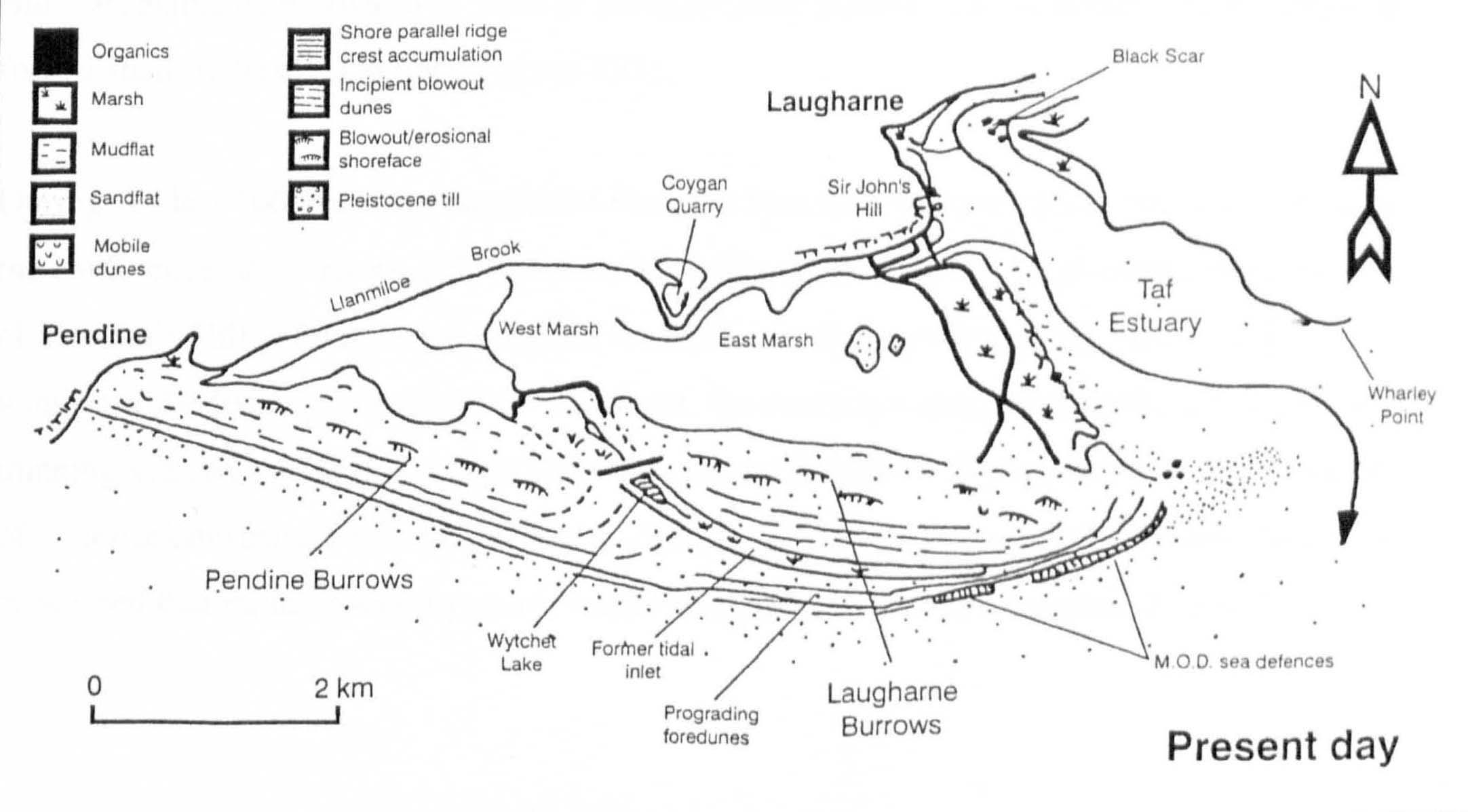
By the second half of the 20th century Pendine and Laugharne Burrows had become a single feature, which continues to prograde. There was concern in the 1970’s over the potential for the system at the distal end of the barrier to break down and breach. As a consequence the MOD installed sea defences, which had the effect of promoting further sedimentation and progradation. Apart from the need to protect infrastructure located within the dunes, it is unlikely that this measure was necessary to safeguard the integrity of the barrier. There is strong evidence that the reclaimed and still accreting marshes and the barrier spit behave according to their reciprocal advantage. The marshes have acted to stabilise the spit by greatly reducing hydrodynamic energy behind it.
There is at present little sign of the flow of sediment into the estuary slowing down, as a consequence the sandflats at the entrance continue to delay tidal ingress, holding it back on the flood and retaining it on the ebb, imposing an identifiably asymmetric tidal cycle.
The research conducted by Walley provides insight into the physical processes against which the growth of the saltmarsh complexes within the Taf Estuary provided suitable conditions for a burgeoning community, but which, as they continued to accrete rendered the harbour inaccessible to all but small draft vessels, smothered those cockle beds immediately accessible on the Laugharne foreshore and forced the decision to construct a wharf for trading vessels closer to the tideway just beyond Dylan Thomas’s Boathouse.
This research has enabled me to understand the hydrodynamic conditions against which the strategic importance of Laugharne developed, flourished and gradually declined, but for insight into the geomorphology of the saltmarshes themselves I have turned to another study: